 |
|

| Attractions | : | Mercer History | : | Regional History | : | Turtle Flambeau History |
SIGNIFICANT FACTS ABOUT MERCER
- Over 200 lakes in a 20 mile radius
- Over 125,000 acres of clean waters teeming with game fish
- Nearly 300 miles of trout streams
- Includes world famous Turtle-Flambeau Flowage, home of bass, trout, walleye, northern, crappies, perch, scrappy bluegills and explosive musky
- 377,900 acres of forest land
- Sand Beaches, cool forests, sun-filled days and brisk nights
- Boating, swimming, hiking, cycling, water skiing, nature study, hunting, ice fishing, archery, golfing, and loon watching
- You'll find it all in Mercer and all set in the natural beauty and serenity of the True Northwoods
 LOON
CAPITAL
LOON
CAPITAL
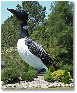
Mercer, c. 1981. How much does a 16 foot loon weigh? The Mercer Loon, which made its debut on May 22, 1981, weighs approximately 2000 pounds. It was erected at the location of the new Mercer Chamber of Commerce building to emphasize Mercer's claim as the “Loon Capital”.
ATTRACTIONS
- New Library and Renovated Community Center
- Carrow Tourist Park on County J - Offers Swimming, Boating, Picnicking & Tennis
- Walleye Run Early in May at Lake of the Falls County Park
- Canoe/Kayak Trails with State Mapped Routes including Turtle River Chain
- 456 miles of Groomed Snowmobile Trails
- Loon Day Art and Craft Fair the First Wednesday of August
- County Fair Last Weekend in August
- Near Major Downhill Skiing Hills
- MECCA Trail System - Cross Country Skiing, Snowshoeing, Hiking, Biking
- Approximately 200 miles of ATV Trails
- 15 Waterfalls
- Northwoods Public Shooting Range
- World's Largest Loon
- Railroad Depot Museum, Caboose and Historical Society
- Over 377,900 Acres of Forest Land for Hunting & Recreation
- Miles of Undeveloped State-owned Shoreline
- Bird & Wildlife Watching
- A 9 Hole Golf Course
- Miniature Golf Course
Geologists traveled through Mercer early in 1848 following the “Flambeau Trail” to the North end of Long Lake from Lake Superior.
The first Mercer school was erected in 1894. It was in this year that the first train arrived in Mercer signaling the beginning of the early settlers, roads, mills, stores and other business.
In 1909, Mercer had its first battle with typhoid fever, while 1911 brought forest fires, burning many acres and threatening lives. 1916 , the fury of a cyclone swept across Long Lake and again in 1920.
The early 1930's saw the Capone brothers, Al, Ralph, George and Matte, vacationing at the Jack Solomon lodge. They were guided by Mitch Babic and Louis Stephy. Ralph Capone returned to Mercer years later, built a home and was one of Mercer's most respected, well-liked residents, always ready to help his fellow townspeople.
Long-time residents tell wonderful stories of coming north on the train, the entire household and livestock in the same boxcar. Of walking miles to Mercer on snowshoes for supplies during snow-in months. Snowplows pulled by five horse teams with men shoveling before the plow so the horses could get through.
Lumbering flourished and Mercer became a well established community in Northern Wisconsin.
In later years, with the decline of lumbering, Mercer became a popular vacation area for fishing and hunting. A naturally beautiful area, with 200 lakes within 20 minutes.
Today, Mercer is known for the natural beauty of its surroundings. Offering quiet, tension free lifestyles for all ages, an excellent school system, legal and medical facilities and strong retail base.
 Wisconsin's first settlers, Paleo-Indians,
entered northern Wisconsin from the south or southwest approximately 10,000
years ago. Paleo-Indian sites in northern Wisconsin are rare and the probability
of finding any archaeological sites within the Turtle-Flambeau Scenic Waters
Area (TFSWA) is unknown.
Wisconsin's first settlers, Paleo-Indians,
entered northern Wisconsin from the south or southwest approximately 10,000
years ago. Paleo-Indian sites in northern Wisconsin are rare and the probability
of finding any archaeological sites within the Turtle-Flambeau Scenic Waters
Area (TFSWA) is unknown.
Archaeologists refer to the various time periods the people inhabited a region as “cultures” and one “Old Copper Culture" site is located north of the flowage. By A.D. 100, the “Hopewell Culture" brought distinctive artifacts and burial customs to Wisconsin. While no sites have been found near the flowage, it is likely that the Hopewell used the Turtle and Flambeau Rivers for transportation. The possibility of finding campsites on high, dry areas bordering the flowage is high.
By the middle of the 17th century, several indigenous groups resided in northern Wisconsin, including the Winnebago, Menominee and Santee Dakota. Nearby, the Huron acted as middlemen between the French fur traders and the people who collected the rich resources in Wisconsin. In 1649, the Huron were displaced by the Iroquois, and a massive westward movement of people ensued. The Chippewa, one of these new groups, settled in northern Wisconsin before the turn of the century.
The expansion of the fur trade stimulated travel throughout northern Wisconsin. In addition, disease and warfare produced a profound reorganization of population and tradition among native groups. Traditional routes through the north woods were expanded and permanent villages were established by major river or trail confluence's. One primary transportation route from Lake Superior into the interior north woods circled the flowage area.
A major Chippewa village located near Mercer was seasonally occupied by the end of the 17th century and permanently occupied from 1763 to at least the reservation period. Local residents remember Chippewa camps near Mercer until the first decades of this century. The closest documented fur trade post was located on Flambeau Lake, approximately 20 miles south. Campsites for collecting and processing of fish, game, rice, maple sugar and possibly birch bark canoes probably existed within the flowage area. Since these camps would probably have been placed along major streams, flooding the flowage may have inundated some sites.
The depletion of animals and fashion changes in Europe ended the fur trade in the mid-19th century. In 1826, the Chippewa sold mineral rights to the United States government but retained land rights. In 1854, the Treaty of LaPointe gave the Chippewas a cash settlement of $90,000 and three reservations. Two of the reservations, the Bad River and the Lac du Flambeau, are partly located in the same county as the flowage. The Chippewas also retained rights to collect food from surrendered lands, and they continued to travel to traditional hunting, fishing and ricing lands today.
With lands now available for development, the federal government, in 1854 and again in 1858, offered railroads inexpensive land to extend rail routes into northern Wisconsin. By 1880, rail lines reached north to Ashland and rail became an important commercial mode of travel in the wooded area.
In the early 1880's iron mining became an important industry in Iron County. In 1882, Edward and John Hayes established the Germania mine on the Montreal River near Hurley.
 The lumber industry, following close on
the heels of the mining industry, largely shaped the history, growth and
physical appearance of Iron County. As stands of pine trees in the central
part of the state were exhausted lumber interests looked for new resources.
Simultaneously, new railroad lines made Iron County accessible for the
first time and the mining boom created a demand for sawn timber to build
mines and the towns that sprang up to support them. Sawmills were established
at Van Buskirk, Gile and Park Falls. Logs from Mercer and Manitowish were
floated down the Manitowish and Turtle Rivers, into the Flambeau River,
to the sawmill.
The lumber industry, following close on
the heels of the mining industry, largely shaped the history, growth and
physical appearance of Iron County. As stands of pine trees in the central
part of the state were exhausted lumber interests looked for new resources.
Simultaneously, new railroad lines made Iron County accessible for the
first time and the mining boom created a demand for sawn timber to build
mines and the towns that sprang up to support them. Sawmills were established
at Van Buskirk, Gile and Park Falls. Logs from Mercer and Manitowish were
floated down the Manitowish and Turtle Rivers, into the Flambeau River,
to the sawmill.
Logging was a high volume industry and a good mill could require up to ten timbered acres a day. By the 1890's most desirable pine trees had been cleared from Iron County. While considerable hemlock and hardwoods, remained, these trees were too heavy to log by current methods. As smaller mills were established closer to areas of hardwood growth and railroad lines, hardwood logging became feasible on a moderate scale. Camps also became more mobile as rail cars increasingly housed various necessities, including the bunk house. This type of logging, only common in Iron County after World War I, ceased by the late 1920's.
Cash crop agriculture never reached significant levels in Iron County; at best, the logging camps and mines in the area created a demand for small scale truck farming. Most farmers were forced to supplement their income by working in the mines or lumber camps in the winter. This dual economy allowed homesteaders to survive in the poor agricultural area. Some settlers turned to subsistence hunting and fishing to supplement a small garden plot. Wildlife in the area was sufficient to provide a constant source of food. Deer, grouse and fish were staples, wild bear, beaver and muskrat were also available.
Hearty crops such as potatoes and rutabagas were grown in the area. Hay was also grown for livestock. By the 1940's and 1950's most of the small, subsistence farms were either abandoned or absorbed by larger operations. Today, dairy farming, especially in more fertile northern Iron County, is the principle agricultural activity and most crop fields grow hay.
Unmanaged logging soon took its toll on the area. The vast barren areas were burned rather than replanted in the hopes of providing good farm land, but farming was clearly not destined to be a major industry in Iron County. The area was more suited for timber management. The Wisconsin State Legislature passed a law in 1927 providing aid and subsidies as incentives for counties to acquire tax delinquent parcels of land to reclaim the woodland and establish county forests. By 1933, over 22,000 acres of county land were entered under the county forest crop law in Iron County; since then, that number has grown to just over 170,000 acres. Today, Iron County forests are primarily managed for timber production as well as wildlife, recreation and watershed protection.
Although hunters and anglers came to Iron County since the early years of the 20th century, it was not until the 1920's and 1930's that they came in significant numbers. Previously, the difficulty of getting to Iron County meant that only the wealthier and more determined could--and would--make the trip. In addition, the first “resorts” were very rough. Little more than logging camps, most resorts were located near rail towns or along major water routes. Hunters and anglers came largely from Milwaukee and Chicago and stayed for a few weeks at a time. Local residents who could no longer find work in the disappearing lumber camps were hired as guides.
Turtle-Flambeau Flowage History
The Turtle-Flambeau Flowage was created in 1926 by the Chippewa and Flambeau Improvement Company (CFIC) as a water retention reservoir to provide flood control and a dependable supply of water for down-stream hydroelectric generating stations. The creation of the Turtle-Flambeau Flowage and improved transportation significantly altered tourism in Iron County. The flowage flooded 16 named lakes and many acres of upland. Many early resorts were located in the area that is now flooded and were forced to move--some to higher ground, others out of the area. As compensation for property lost during the land acquisition stage, property owners were offered money or land. Since most chose to take the cash settlement, the land along the flowage today is very sparsely developed.
The flowage, in turn, also attracted tourists. What had been good fishing before became even better, and more people came to test the waters. In the 1930's, a large Civilian Conservation Corp (CCC) camp was established in the Mercer-Manitowish area (Camp 79S, Company 660). The CCC, along with the Works Progress Administration (WPA), cleared the land, improved and paved roads, and began to manage the remaining forest lands and replant areas that had been logged. This made the area more accessible and popular to tourists, and many new resorts opened to service them.
Over the years, these resorts have had many visitors, some of them notorious, adding some interesting fodder to the area's history. John Dillinger frequented the area. Al Capone, the Chicago gangster, fished in the flowage area many times, especially in the years after he was released from prison. Charlie Comiskey, founder of the White Sox baseball team, used Jerome's Hunting and Fishing Club on Trude Lake as a place for rest and relaxation for himself and his team.
Interesting Links for
the Mercer Wisconsin area:
Turtle-Flambeau
Flowage Association
