Wisconsin USA
Wisconsin is located between the Great Lakes and the Mississippi River and is home to a wide variety of geographical features.
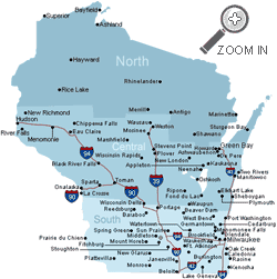
There are five different regions. The Lake Superior Lowland in the north occupies a strip of land along Lake Superior. Below this, the Northern Highland has huge mixed hardwood and coniferous forests including the 1.5 million acre (6,000 km2) Chequamegon-Nicolet National Forest, and thousands of glacial lakes, and features Timms Hill the state's highest point. In the middle, the Central Plain has unique sandstone formations - the Dells of the Wisconsin River - in addition to rich farming land. The Eastern Ridges and Lowlands region in the southeast are home to most of Wisconsin's largest cities. In the southwest, the Western Upland is a mix of forest and farmland, including many bluffs on the Mississippi River. This region is part of the Driftless Area in southwestern Wisconsin is characterized by bluffs carved in sedimentary rock by water from melting Ice Age glaciers. 46% of Wisconsin's land area is covered by forest.
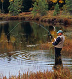
Wisconsin is a popular vacation destination for outdoor recreation, including skiing, ice fishing and snowmobile derbies. Wisconsin has many lakes and contains 11,188 square miles (28,977 km2) of water. Only Alaska, Michigan and Florida have more. The distinctive Door Peninsula, which extends off the eastern coast of the state, contains one of the state's most beautiful tourist destinations, Door County. The area draws thousands of visitors yearly to its quaint villages, seasonal cherry picking, and ever-popular fish boils.

![]() Women are not allowed to wear anything red in public!
Women are not allowed to wear anything red in public!

